

Introduction
Agriculture Industrial Drones
The world population has increases day by day and projected to reach 9 billion people by2050, so that the agricultural consumption will also increase. There is urgent need tofulfil the food demand of each and every person. Agriculture sector is the most promisingsector, dealing with the lot of problems now a day‟s one of the innumerable problems islabour unavailability for farming. Other problems or difficulties are extreme weather events.
Inadequate amount and inefficient application of fertilizer, infection, diseases, allergies and other health problems due to chemical application (fungicide, pesticide, insecticideetc.) or insect/ animal bite.
Climate change is having a major impact on food security. More than 815 million people are chronically hungry and 64 percent of the chronically hungry are in Asia. The world needs to increase food production by almost 50 percent by 2050 to feed a population of nine billion, yet resources such asland and water are becoming more and scarcer.
Farming communities and others involved in agriculture have to adapt agriculture to climate change and other challenges. In this context, ICT-driven tools and technologies to enhance decision making through accurate, reliable and timely information have an important role to play. Agriculture has to look towards emerging technologies for solutions to overcome some of the challenges facing it.
Technological progress made in monitoring, supervision, management and control systems have opened a new era in which many traditional agricultural practices are outdated. Their replacement with new technologies falls into the "precision farming" category, which translates into applying the agronomic variables in the right place, at the right time and with precise control over the amount of material inputs or crop production.
FAO and ITU, together with partners, have been working together in addressing same of the challenges faced in agriculture through the use of sustainable ICTs. Unmanned aircraft proved to be one of those techniques that allow rapid and non- destructive analysis of air quality, physical properties of the components of soil or crop growth.
“In the current milieu, use of sustainable information and communication technology in agriculture in not an option. It is a necessity.
Drones and agriculture
Drones are transforming how agriculture and farming are done. By implementing drone technology, farms and agriculture businesses can improve crop yields, save time, and make land management decisions that‟ll improve long-term success.
Farmer‟s today have a variety of complex factors that influence the success of their farms. From water access to changing climate, wind, soil quality, the presence of weeds and insects, variable growing seasons, and more. As a result, farmers are turning to highlevel drone technology to help remedy these problems, and provide fast and efficient solutions.
Agricultural drones allow farmers to obtain access to a wealth of data they can use to make better management decisions, improve crop yields, and increase overall profitability. Drones can be used to collect data related to crop yields, livestock health, soil quality, nutrient measurements, weather and rainfall results, and more. This data can then be used to get a more accurate map of any existing issues, as well as create solutions based upon extremely reliable data.
The agriculture industry is no stranger to embracing changing technological trends to streamline business. The use of drones in agriculture is the next technological wave that‟ll help agricultural businesses meet the changing and growing demands of the future. The United Nations has experimented with drones in various areas of its mandate ranging from humanitarian crises to agriculture. For example, the World Food Programme (WFP) has joined with the Belgian government to deploy drones in humanitarian emergencies (WFP, 2017).
The usefulness of drones to facilitate quick data collection with greater accuracy together with providing a safer monitoring system in emergencies was a key element in testing this in the field during challenging humanitarian crises. FAO and Google (FAO, 2016) have partnered to make remote sensing data more efficient and accessible. Access to quality data is the key to making effective policies and interventions towards the achievement of the Sustainable Development Goals by 2030. The use of drones in agriculture is extending at a brisk pace in crop production, early warning systems, disaster risk reduction, forestry, fisheries, as well as in wildlife conservation, for example.
Applications of drone in agriculture Soil and field analysis
At the every stage of crop cycle drones can be used to help obtain useful data. By obtaining 3D maps of existing soil, we will be able to monitor potential soil quality, nutrient management, or soil dead zones. This information can help farmers determine the most effective patterns for planting, managing crops, soil, and more. Ongoing monitoring can help to better utilize water resources, and more effectively manage crop nutrient levels.
Seed planting
Drone planting is a newer technology and not as widely used, but some firms are experimenting with drone planting. Essentially, manufacturers are experimenting with custom systems that have the ability to shoot seed pods into prepared soil. Drone startup companies have been instrumental in developing unique drone technologies to assist with a wide range of ecological and agricultural issues. E.g.- Droneseed. This same drone technology can be adapted and applied to a wide range of farm types, reducing overall planting times and labor costs across the board.
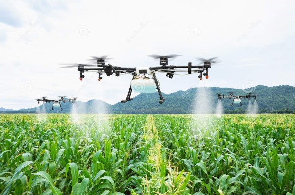
Crop spraying and spot spraying
This is most important operation in crop life cycle. Crops require regular fertilization and spraying in order to maintain high yields. Traditionally this was done manually, with vehicles, or even via airplane (in some parts of the world). These methods are not only inefficient, and burdensome, but they can be very costly as well. Drones can be equipped with large reservoirs, which can be filled with fertilizers, herbicides, or pesticides. Using drones for crop spraying is much safer and cost effective. Drones can even be operated completely autonomously and programmed to run on specific schedules and routes.
Crop mapping and surveying
One of the great advantages of drone technology is the effectiveness of large-scale crop and acreage monitoring. In the past, satellite or plane imagery was used to help get a large scale view of the farm, while helping to spot potential issues. However, these images were not only expensive but lacked the precision that drones can provide. Today, you can not only obtain real-time footage but also time-based animation which can illuminate crop progression in real-time. With drone mapping and surveying, technology decisions can now be made based on real-time data, not outdated imagery, or best-practice guesswork. With near infrared (NIR) drone sensors you can actually determine plant health based upon light absorption, giving you a birds-eye view of the overall farm health. With agriculture drones we will be able to collect information like overall crop and plant health, Land distribution based on crop type, crop life cycle, detailed GPS maps of current crop area .
Irrigation monitoring and management.
Irrigation is always been troublesome for farmers. With miles and miles of irrigation, issues are bound to arise. Drones that are equipped with thermal cameras can help to spot irrigation issues, or areas that are receiving too little or excessive moisture. With this information, crops can be better laid out to maximize drainage, adhere to natural land runoff, and avoid water pooling, which can damage sensitive crops. Water and irrigation issues are not only costly but can ruin crop yields as well. With drone surveying, these issues can be spotted before they becometroublesome.